![](/images/other/stat-length.png)
![Trail Walking La Clusaz - trou de la mouche - Photo](https://media.geolcdn.com/t/1900/400/d1c53166-b5e9-47a4-8610-413d94234e56.jpg&format=pjpeg&maxdim=2)
trou de la mouche
gamille67
User
![Length](/images/other/stat-length.png)
Length
8.2 km
![Max alt](https://static1.geolcdn.com/siteimages/upload/files/1508320355ic_sort_altitude_max_24dp.png)
Max alt
2440 m
![Uphill gradient](https://static1.geolcdn.com/siteimages/upload/files/1508320355ic_sort_den_pos_24dp.png)
Uphill gradient
985 m
![Km-Effort](/images/other/stat-length.png)
Km-Effort
21 km
![Min alt](https://static1.geolcdn.com/siteimages/upload/files/1508320355ic_sort_altitude_min_24dp.png)
Min alt
1438 m
![Downhill gradient](https://static1.geolcdn.com/siteimages/upload/files/1508320355ic_sort_den_neg_24dp.png)
Downhill gradient
1013 m
![Boucle](https://static1.geolcdn.com/siteimages/upload/files/16400158638029165_repeat_loop_refresh_sync_direction_icon.png)
Boucle
No
Creation date :
2021-06-26 08:11:23.844
Updated on :
2021-06-26 14:39:11.756
![Walking](https://static1.geolcdn.com/sitytour/trail-icons/101.png)
4h29
Difficulty : Difficult
![Scan this QR Code to open this trail in the SityTrail application](https://capi.geolives.com/qq0zvz2zws4bq2lad0pu/sitytour/trails/2840127/qr.png?size=200)
FREE GPS app for hiking
About
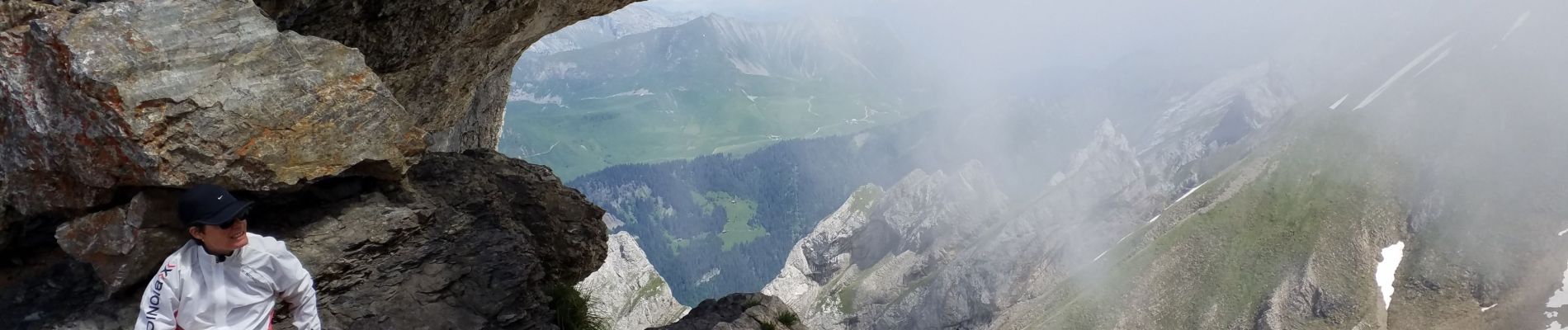
Trail Walking of 8.2 km to be discovered at Auvergne-Rhône-Alpes, Upper Savoy, La Clusaz. This trail is proposed by gamille67.
Description
moins de deux heures pour la montée, un peu moins mais à peine pour la descente, le reste au sommet.
Positioning
Country:
France
Region :
Auvergne-Rhône-Alpes
Department/Province :
Upper Savoy
Municipality :
La Clusaz
Location:
Unknown
Start:(Dec)
Start:(UTM)
305067 ; 5088350 (32T) N.
Comments
Trails nearby
![Trail Walking La Giettaz - Le Plan - col de Jaillet - Photo](https://media.geolcdn.com/t/375/260/ext.jpg?maxdim=2&url=https%3A%2F%2Fservices.sitytrail.com%2FGeolivesWS%2FDownloadMedia.ashx%3FTrailID%3D333788%26Media%3D20140812144015.jpg)
![Walking Walking](https://static1.geolcdn.com/sitytour/trail-icons/101.png)
Le Plan - col de Jaillet
Walking
Medium
(2)
La Giettaz,
Auvergne-Rhône-Alpes,
Savoy,
France
![](/images/other/stat-length.png)
11.9 km | 19.7 km-effort
4h 18min
![](https://static1.geolcdn.com/siteimages/upload/files/16400158638029165_repeat_loop_refresh_sync_direction_icon.png)
Yes
![Trail Walking La Clusaz - 74.trou de la mouche la Clusaz août 2022 - Photo](https://media.geolcdn.com/t/375/260/013ecbc8-ff05-411a-964c-f1dce6454639.jpg&format=jpg&maxdim=2)
![Walking Walking](https://static1.geolcdn.com/sitytour/trail-icons/101.png)
74.trou de la mouche la Clusaz août 2022
Walking
Medium
La Clusaz,
Auvergne-Rhône-Alpes,
Upper Savoy,
France
![](/images/other/stat-length.png)
9.5 km | 24 km-effort
5h 32min
![](https://static1.geolcdn.com/siteimages/upload/files/16400158638029165_repeat_loop_refresh_sync_direction_icon.png)
Yes
![Trail Touring skiing Le Grand-Bornand - PT 2595au dessus du col des Verts - Photo](https://media.geolcdn.com/t/375/260/adf344e5-4ea3-43cf-966b-fc21b915cec5.jpg&format=jpg&maxdim=2)
![Touring skiing Touring skiing](https://static1.geolcdn.com/sitytour/trail-icons/503.png)
PT 2595au dessus du col des Verts
Touring skiing
Difficult
Le Grand-Bornand,
Auvergne-Rhône-Alpes,
Upper Savoy,
France
![](/images/other/stat-length.png)
14.2 km | 33 km-effort
5h 54min
![](https://static1.geolcdn.com/siteimages/upload/files/16400158638029165_repeat_loop_refresh_sync_direction_icon.png)
Yes
![Mountain bike Mountain bike](https://static1.geolcdn.com/sitytour/trail-icons/202.png)
vtt-dans-la-vallee-du-bouchet
Mountain bike
Very easy
Le Grand-Bornand,
Auvergne-Rhône-Alpes,
Upper Savoy,
France
![](/images/other/stat-length.png)
7.5 km | 10.5 km-effort
Unknown
![](https://static1.geolcdn.com/siteimages/upload/files/16400158638029165_repeat_loop_refresh_sync_direction_icon.png)
No
![Mountain bike Mountain bike](https://static1.geolcdn.com/sitytour/trail-icons/202.png)
VTT du grand bornand au refuge
Mountain bike
Very easy
Le Grand-Bornand,
Auvergne-Rhône-Alpes,
Upper Savoy,
France
![](/images/other/stat-length.png)
25 km | 38 km-effort
Unknown
![](https://static1.geolcdn.com/siteimages/upload/files/16400158638029165_repeat_loop_refresh_sync_direction_icon.png)
Yes
![Mountain bike Mountain bike](https://static1.geolcdn.com/sitytour/trail-icons/202.png)
Le_Grand_Bornand_20210706_104522
Mountain bike
Very easy
Le Grand-Bornand,
Auvergne-Rhône-Alpes,
Upper Savoy,
France
![](/images/other/stat-length.png)
18.4 km | 29 km-effort
Unknown
![](https://static1.geolcdn.com/siteimages/upload/files/16400158638029165_repeat_loop_refresh_sync_direction_icon.png)
Yes
![Trail Walking La Clusaz - Les Converses, Le Planet, Beauregard, les Corbassières (boucle) - Photo](https://media.geolcdn.com/t/375/260/fc969c4d-6540-4dae-ad1a-e21a9acad593.jpg&format=jpg&maxdim=2)
![Walking Walking](https://static1.geolcdn.com/sitytour/trail-icons/101.png)
Les Converses, Le Planet, Beauregard, les Corbassières (boucle)
Walking
Difficult
La Clusaz,
Auvergne-Rhône-Alpes,
Upper Savoy,
France
![](/images/other/stat-length.png)
10.4 km | 17.7 km-effort
3h 11min
![](https://static1.geolcdn.com/siteimages/upload/files/16400158638029165_repeat_loop_refresh_sync_direction_icon.png)
Yes
![Trail Walking Le Grand-Bornand - Refuge Gramusset à partir de la Duche - Photo](https://media.geolcdn.com/t/375/260/73111a9a-0fbf-415b-b1f6-9a526784c3a6.jpg&format=jpg&maxdim=2)
![Walking Walking](https://static1.geolcdn.com/sitytour/trail-icons/101.png)
Refuge Gramusset à partir de la Duche
Walking
Le Grand-Bornand,
Auvergne-Rhône-Alpes,
Upper Savoy,
France
![](/images/other/stat-length.png)
12.7 km | 23 km-effort
4h 32min
![](https://static1.geolcdn.com/siteimages/upload/files/16400158638029165_repeat_loop_refresh_sync_direction_icon.png)
Yes
![Mountain bike Mountain bike](https://static1.geolcdn.com/sitytour/trail-icons/202.png)
Le_Grand_Bornand_20200623_090207
Mountain bike
Very easy
Le Grand-Bornand,
Auvergne-Rhône-Alpes,
Upper Savoy,
France
![](/images/other/stat-length.png)
26 km | 38 km-effort
Unknown
![](https://static1.geolcdn.com/siteimages/upload/files/16400158638029165_repeat_loop_refresh_sync_direction_icon.png)
No